



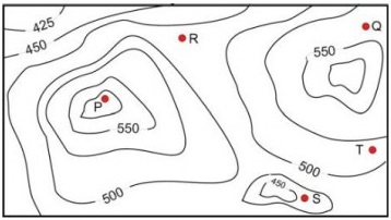
A contour line joins locations having the same height above the mean sea level. The following is a contour plot of a geographical region. Contour lines are shown at m intervals in this plot. If in a flood, the water level rises to m, which of the villages get submerged?
View worked solution
Answer: C
A contour line joins locations of equal elevation above mean sea level. A village will get submerged if its elevation is strictly less than the flood water level of .
By analyzing the contour lines (which are spaced at intervals):
- Village : Located inside the contour line.
- Village : Located between the and contour lines.
- Village : Located between the and contour lines.
- Villages and : Located outside the contour line on the lower elevation side.
Therefore, the villages that get submerged are .
Free practice · Your answers on this page are not saved.